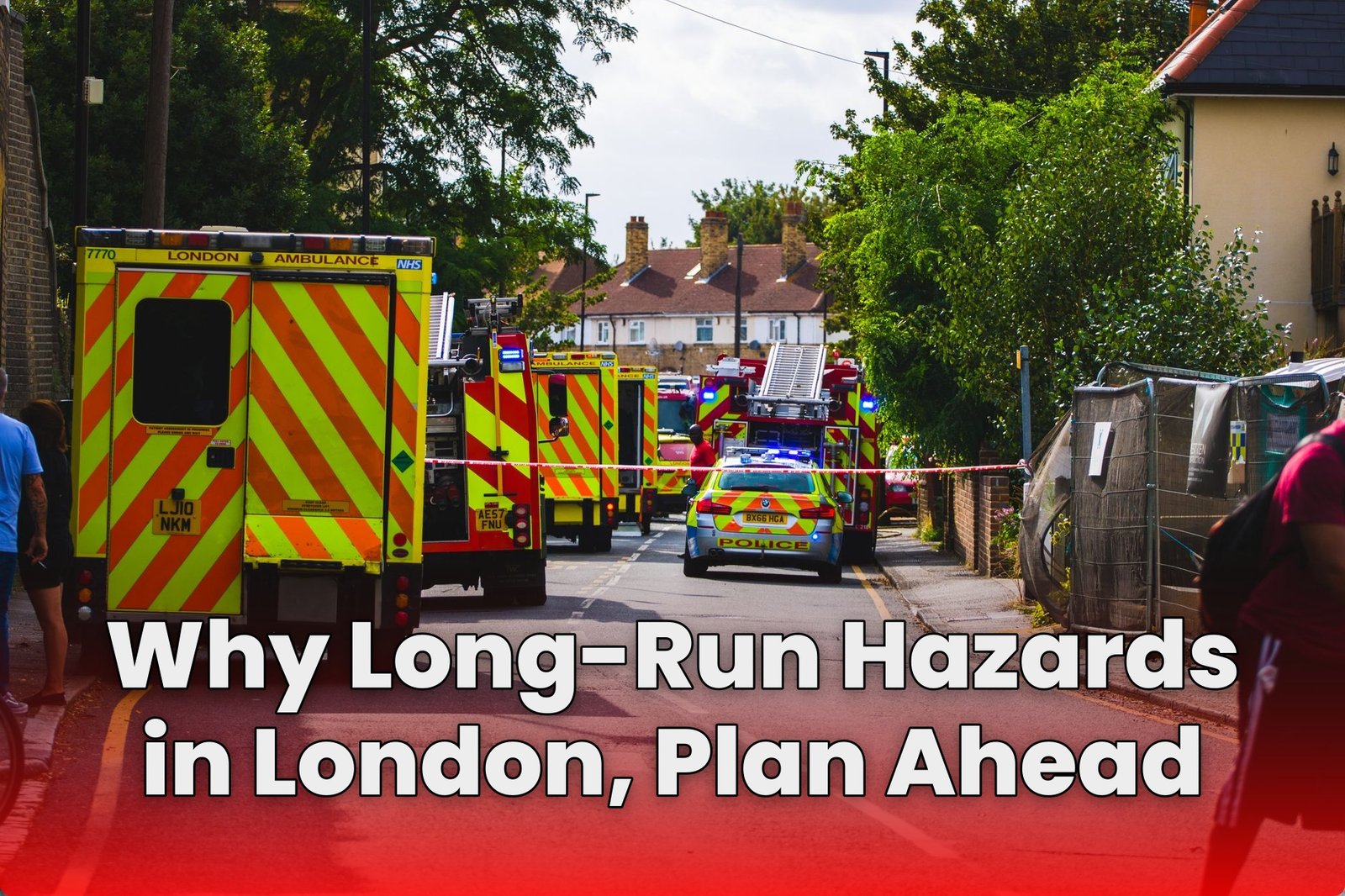
London does not punish preparation, it rewards it. Too many people wait for a disruption to make plans, and then they blame “bad luck” when services wobble or routes become unsafe. The smarter stance is simple: treat long-run hazards as predictable risk, then map around them early so decisions stay calm, fast, and rational when conditions change.
Long-run threats in London are not limited to one category. Severe weather and localized flooding near the Thames, electricity and telecommunications failures, cyber incidents, human disease, and even wider shocks like civil disorder or terrorism can all create the same practical outcome: delays, communication gaps, and confidence loss. When you plan only for the obvious, you get surprised by the compounding effects that follow system failures.
This article argues for a planning approach that starts before the next emergency. Use hazard categories to pre-plan contingencies, identify where conditions commonly worsen on the ground, and set reroute rules for both daylight and night-time realities like poorly lit stretches. Then validate those plans with the latest local guidance, so closures, works, or park access changes do not force last-minute chaos.
Stop Treating London Like It Is Predictable
London has a talent for surprise. That is not drama, it is statistics plus geography. The city’s common long-run hazards include severe weather, electricity network failure, telecommunications failure, human disease including pandemic flu, civil disorder, terrorism, cyber incidents, and severe space weather. If you plan as though none of that will matter to you, you are not being calm. You are being unprepared.
Risk does not need to be frequent to be harmful. A low-probability event can still break your week, strand you mid-route, or force decisions under pressure. So the real question is simple: will you prepare in advance, or improvise while conditions worsen?
Use Hazard Categories Instead of Vibes
The biggest mistake is treating preparedness like a mood. You do not need feelings, you need categories you can act on. At the national level, the UK National Risk Assessment is updated every two years and sets out major hazards for preparation over a five-year horizon. Locally, the City of London Resilience Forum identifies threats and hazards that could trigger emergencies in the Square Mile within the next five years.
When your planning framework matches the hazard categories used by risk professionals, you reduce guesswork. You also gain a common language for what to check first, what to pause, and what to reroute. That is how map around them early stops being a slogan and becomes a routine.
Flooding Risk Is Location-Specific and Mostly Surface Water
It is tempting to assume “flooding” means the Thames overflows with cinematic drama. In the Square Mile, physical risk is largely classed as very low. But areas nearer the Thames, such as Walbrook Wharf, face low annual chance of flooding around 0.1% to 1%.
Here is the part that matters for planning: the most relevant flood risk is often heavy-rain surface-water flooding. That means fast onset, local pooling, and blockages that do not always show up in broad regional weather headlines. If your plan only reacts to river levels, you are reacting late.
Electricity and Telecom Failures Can Ruin the Day Quickly
Electricity network failure and telecommunications failure are not abstract. They hit in the places where you rely on live updates, payments, ticketing, and wayfinding. Even if physical conditions are manageable, the loss of connectivity turns normal routes into guesswork.
Plan for this like a power cut and a network outage are plausible in the same week, because they are. Have offline options, identify alternate meeting points, and decide in advance what “go/no-go” looks like when screens are unhelpful. If remote work productivity were the issue, you would plan for software outages. For London hazards, the logic is identical.
Human Disease Planning Must Be Operational, Not Symbolic
Human disease including pandemic flu is on the long-run hazard list for a reason: it spreads through routines. London is dense, transit is shared, and social schedules are sticky. When a health risk rises, the damage is not only medical. It is logistical.
So do not treat disease planning as a document you keep for reassurance. Build operational steps: contingency for sickness coverage, clear hygiene expectations, and a rule for when to change route density or timing. Hope is not a mitigation strategy.
When Disorder or Terror Hits, Your Decision Rules Matter
Civil disorder and terrorism are rare, but they are decisive. The people who recover fastest are not those who predicted the event perfectly. They are those who already know what they will do in the first minutes: where to pause, how to check trusted information, and when to divert.
| Hazard Type | Early Signals | Contingency Window |
|---|---|---|
| Civil Disorder | Major road closures | Re-route within 30 minutes |
| Terror Threat | Security cordons | Switch plans within 15 minutes |
| Public Transport Disruption | Service suspension | Decide within 20 minutes |
| Large Crowd Event | Access restrictions | Adjust within 45 minutes |
| Emergency Alerts | Official guidance posted | Act same hour |
This is why common long-run hazards in london need to become decision rules, not just reading material. If you wait for certainty, you will lose mobility and options. If you prepare thresholds, you keep control.
And for those who want an external reference, the most practical baseline is the risk register updates that authorities publish and refine over time.

Cyber Incidents Turn “Normal Life” into a Trap
Cyber incidents are often treated as a tech problem. They are also a public-systems problem. When systems fail, the knock-on effects are predictable: outages in communications, reduced access to information, and delays that compound into real-world disruption.
For route planning and contingency thinking, cyber risk should change how you act, not just what you read. Assume that some of your information flow may break. Prepare paper alternatives, offline maps, and a simple escalation chain so you are not stuck refreshing apps while conditions shift.
Severe Space Weather Is Quiet Until It Isn’t
Severe space weather can disrupt communications, navigation, and power systems. It is not a London-only hazard, but London is an operational hub that depends on infrastructure and timing. When signals and timing mechanisms degrade, downstream systems struggle.
So plan for degraded connectivity and timing drift in your operational assumptions. If your plans rely on precise schedules, build buffers. If your plans require synchronized updates, define when you will proceed with last-known-good information and when you will stop and reassess.
Night-Time Hazards Demand Real Route Mapping
Many planners handle daytime risk and ignore night-time hazards. That is a mistake. Poorly lit stretches, dim park paths, and unlit segments along river or park routes can make the same route dramatically more dangerous after dark.
Map around them early by identifying the weak points on your route in advance. Then build reroute logic that does not depend on last-minute visibility. Ask yourself: if the path is dark and someone is injured, do you still have a safe alternative that you would recognize in poor conditions?
Check Closures and Guidance Before You Start Moving
Scheduled works, closures, and changing conditions are among the most common “hidden triggers” of disruption. They are not always loud, and they can change quickly. The difference between a smooth journey and a frustrating one is often whether you checked the relevant guidance immediately before leaving.
Use local references like Thames Path guidance for scheduled works or closures, and check park opening hours when your route passes through green space. Pre-plan reroutes so you are not forced into a risky detour when your original path becomes unavailable.
Build Contingencies as Specific Paths, Not Vague Intentions
A contingency that says “go another way” is not a contingency. It is a hope. London requires specificity because hazards are localized. Surface-water flooding near the Thames can turn a familiar segment into a bottleneck in minutes, while other nearby streets remain fine.
So treat mapping as a set of prepared alternatives: primary route, short detour, and full reroute. Give each option a clear trigger, such as “switch when the crossing area is blocked” or “avoid the unlit segment when visibility drops.” You do not need more information. You need more actionable options.
Practice the Plan Under Stress
Preparedness fails at the exact point you need it most, the moment your normal routine breaks. That is why you should practice your reroute logic and communication chain before any hazard arrives. Run a short drill that simulates low visibility, limited connectivity, and a sudden closure.
If you cannot execute your plan quickly when conditions are worse, your plan is just paperwork.
Update Your Map Every Two Years and After Big Changes
The National Risk Assessment is updated every two years, and local assessments also evolve as the city changes. If your hazard map is frozen in time, it will drift away from reality. Equipment ages, infrastructure changes, and new works alter the routes people actually use.
Keep the system living. Refresh your route alternatives when closures and lighting patterns change, and re-check assumptions after major infrastructure incidents. Map around them early by treating your plan as a recurring task, not a one-off project.
How Can You Map Around Common Long-Run Hazards in London Early?
How Can You Identify London’s Common Long-Run Hazards and Map Around Them Early?
Start with official hazard frameworks, then convert them into practical checkpoints: review the UK National Risk Assessment’s five-year horizon, check local guidance from bodies like the City of London Resilience Forum, list likely triggers (weather, infrastructure failure, disease, disorder/terrorism, cyber, space weather), and build contingency routes and check-in routines for each scenario.
What Flooding and Severe Weather Areas in London Should You Map Around First?
Prioritize known flood-prone zones near the Thames and low-lying areas, focusing on the most relevant mechanism (for many riverside locations, heavy-rain surface-water flooding), then add weather-based detours for high-wind disruption and travel delays, using local alerting sources and regularly updated closure information to reroute before conditions worsen.
How Should You Prepare for Electricity Network and Telecommunications Failures in London?
Plan for loss of power and connectivity by mapping “offline” options: carry paper alternatives for key contacts and directions, store essential supplies and chargers, identify backup communication paths, and choose routes that still function during outages while keeping transport and venue status under frequent review.
What Health Risks, Including Pandemic Flu, Should You Plan for in London?
Build a health-focused checklist around public health guidance: track local infection updates, maintain basic hygiene and preventive supplies, ensure you have medications and contingency accommodation or work alternatives, and prepare to adjust movement plans quickly during surges or pandemic measures.
How Can You Map Around Civil Disorder, Terrorism, and Safer Routes in London?
Use layered situational awareness: monitor official threat and disruption advisories, avoid predictable “pinch points” during tense periods, pre-plan alternate walking or transit routes, and choose lighting, footfall, and staffing cues that reduce risk, while keeping an emergency contact and meeting point ready.
How Do Space Weather Events and Night-Time Visibility Issues Affect Your London Contingency Plans?
Include low-probability, high-impact disruption in your plans by tracking space-weather communications and infrastructure advisories, and pair that with “practical night” checks—poorly lit stretches, park opening hours, and scheduled Thames Path works or closures—so you can reroute early when visibility or access conditions change.
Map Risks Early In London And Stay Ready
London demands practical planning for the common long-run hazards in london, map around them early, because the threats that disrupt power, phones, transport, public health, and safety tend to hit in overlapping waves. Build your contingency routes and backups around known risks like severe weather, electricity and telecommunications failure, human disease and pandemic flu, civil disorder and terrorism, cyber incidents, and severe space weather, and treat local reality seriously by planning around Thames-side surface-water flooding hotspots and poorly lit night routes or any Thames Path and park closures. The smart move is simple: plan before the disruption, so you can adapt without panic when it arrives.
I am Ozan, a London-focused running writer and marathon enthusiast with a passion for helping people discover the city’s best races, running routes, walking trails, and fitness events. I research and write practical, up-to-date guides covering marathons, race preparation, training tips, running gear, and everything related to staying active in London.
My goal is to create reliable, easy-to-follow content that helps runners and walkers of all experience levels explore London with confidence, whether they’re preparing for their first 5K or their next marathon.